7.7 Earthquake Kills 47 in Indonesia's Flores Island
Meta description for search results, 120-158 characters
At least 47 people have been killed after a magnitude 7.7 earthquake struck the Indonesian island of Flores shortly before 05:00 local time on Saturday, according to the country’s National Disaster Management Agency (BNPB). The toll was still rising as search and rescue teams worked through the day, and hundreds of buildings across the region have been damaged.
The quake struck at a depth of 15 kilometers, Indonesia’s meteorology and geophysics agency said. Shallow earthquakes tend to cause more severe surface damage than deeper ones, because the energy has less distance to travel before it reaches buildings and ground surfaces.
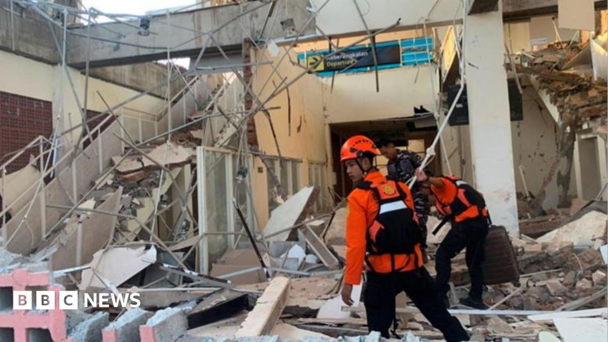 Photo: bbc-world
Death toll by province
BNPB said the fatalities were concentrated on Flores and in surrounding provinces of East Nusa Tenggara: 24 deaths in Manggarai, 17 in East Manggarai, three in Sikka, and at least one each in Ngada, Ende, and West Manggarai. At least two other people were seriously injured and 11 slightly injured, the agency said.
Emanuel Melkiades Laka Lena, governor of East Nusa Tenggara province, told a news conference that many victims were killed in their sleep by collapsing rubble, according to BBC News.
More than 150 houses have been severely damaged, along with dozens of schools, healthcare facilities, places of worship, offices, and other public buildings, BNPB reported. The full extent of the destruction is not yet known — the affected area is remote and mountainous, which slows both assessment and access for rescue crews.
Tsunami warning issued, then lifted
Authorities issued a tsunami warning within minutes of the quake. Video from the port in Maumere, cited by the BBC, showed large chunks of concrete breaking off the terminal building onto passengers waiting to board an inter-island ferry; some people were thrown into the sea when the gangway to a ship collapsed.
Arnold Welianto, a resident of Talibura village near the coast in Sikka, told the BBC he was woken by “very strong shaking” and went straight to check on his child. He said the sea receded and stayed low for some time, which set off a panic: “everyone panicked and ran,” he said, and many residents fled into the hills. BNPB said roughly 2,000 people evacuated or relocated on their own.
The tsunami warning was lifted about three hours after the initial jolt, once monitoring agencies detected no significant sea-level rise.
Aftershocks keep residents outdoors
Dozens of aftershocks followed the main shock, including a magnitude 6.4 earthquake in North Sumatra — more than 1,500 kilometers away, on the opposite end of the archipelago — at a depth of 163 kilometers, per BNPB. The US Geological Survey measured that same aftershock at magnitude 6.9.
Welianto said many Talibura residents were staying outdoors because continued aftershocks made them afraid to go back inside. Yulian Juita Ekalia, a university lecturer from Ruteng, west of the epicenter, told AFP she had dragged her stove outdoors to cook rather than risk her kitchen. “I have never felt an earthquake this big,” she said. “It felt like we were on a trampoline — it was really scary.”
 Photo: FluxrBot illustration
Why this shows up on catastrophe risk markets, not just news wires
Indonesia lies at the junction of three tectonic plates — the Indo-Australian, Pacific, and Eurasian — a setup that produces frequent, often shallow earthquakes across the archipelago. That geology is also why Indonesia has been a proving ground for parametric catastrophe insurance: coverage that pays out automatically once a quake hits a pre-agreed magnitude and depth threshold at a given location, rather than waiting on a traditional loss assessment. The World Bank’s Southeast Asia Disaster Risk Insurance Facility, which Indonesia participates in, was built specifically around this kind of trigger-based payout for the region.
Saturday’s quake struck roughly 600 miles east of Bali, in an area that facility’s models treat as high-frequency risk. A shallow 7.7 event with a confirmed provincial death toll and over 150 homes destroyed is close to the threshold where parametric triggers activate — magnitude and depth are exactly the two inputs those contracts price on. It’s the same logic that underpins prediction-market-style event contracts more broadly: a defined, verifiable trigger determines the payout, not a subjective damage estimate. Readers curious how that pricing mechanism works in practice can see the mechanics laid out in our field guide to reading event-contract odds as probabilities.
BNPB has advised residents to remain calm, stay away from coastal areas, and avoid structures showing visible damage. Aid is being routed to the affected provinces, the agency said.
The death toll is likely to change as rescue teams reach more remote villages in the mountainous interior of Flores.
FAQ
How many people died in the Indonesia earthquake?
At least 47 people have been killed, according to Indonesia’s National Disaster Management Agency (BNPB), with the toll concentrated in Manggarai, East Manggarai, Sikka, Ngada, Ende, and West Manggarai provinces. The agency says the number is likely to rise as rescue teams reach remote areas.
Was there a tsunami after the Indonesia earthquake?
Authorities issued a tsunami warning immediately after the 7.7 magnitude quake struck near Flores. It was lifted about three hours later after monitoring agencies detected no significant rise in sea level, though the sea did recede noticeably along parts of the coast, prompting residents to flee inland.
Where did the Indonesia earthquake strike?
The quake struck the island of Flores in eastern Indonesia’s East Nusa Tenggara province, about 600 miles east of Bali, shortly before 05:00 local time on Saturday. It had a shallow depth of 15 kilometers, which tends to produce more severe surface damage.